Suggested maps for Helvellyn – OS Explorer Map OL5 (1:25,000) & OS Landranger Map 90 (1:50,000)
This route does carry an element of risk and sadly people have been injured and died on the ascent and descent of Helvellyn via Striding and Swirral Edge. It is not a route to be attempted in bad weather unless you know what you are doing and have the right equipment.
This walk, via Striding Edge, is one of my favourite in the Lakelands. I first did this as a child age 7 anti clockwise via Swirral Edge with my dad. The route described here is the classic clockwise ascent, albeit with a slightly different approach to Striding Edge to take in the beautiful Grisedale Valley.

Glenridding
The starting point is the scenic Glenridding Village situated on the banks of Ullswater. There is ample parking here (GRID NY385169) and you can pay online, even after you have left! From here walk back to the main road through Glenridding (The A 592) and cross the bridge onto the south side of the beck. Follow the beck heading east past the shops and houses and into a wooded area until you come to a fork in the path at GRID NY383167. The traditional route follows the right path here to head up the side of Birkhousemoor but here we turn left and start ascending through a patch of ferns heading towards Lanty’s Tarn at GRID SY383163. From here pass a small rocky outcrop heading south then turn right and follow the prominent path north west up the northern side of the Grisedale Valley to the ‘Hole in the Wall’ at GRID SY359154.
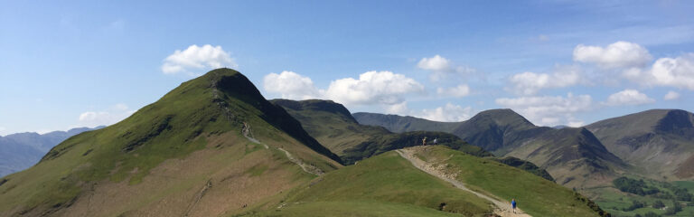
Striding EdgE
From the ‘Hole in the Wall’ continue up onto Striding Edge (there is a path that contours Striding Edge below the ridgeline for anyone less confident). Striding Edge is a classic 1.5km ridge walk which offers fantastic views of the surrounding fells, valley’s and tarns. The legendary guidebook author Alfred Wainwright thought this was the finest ridge the Lake District has to offer and had this to say in his Pictorial Guide to the Lakeland Fells, Book 1 – The Eastern Fells:
“..Striding Edge is all bare rock, a succession of jagged fangs ending in a black tower. The Edges are bounded by deep rough hollows, silent and very lonely. “

The British Mountaineering Council offer a great guide to climbing Striding Edge if you want to learn more but continue to the top of the Edge and follow the narrow path towards the Helvellyn massif. Towards the end of the Edge, and just before the final ascent, there is a 7m scramble descent known as the Chimney. It isn’t too taxing but just remember the golden rule of 3 Points of Contact at all times.

Helvellyn Summit
The final ascent to the 950m summit of Helvellyn is a simple scramble and in places some steps have been cut in to aid you. Once the ground starts to flatten out it is a short walkover shale to the summit Carn at GRID NY342151. Aside from the amazing view and rejoicing in the exhilaration of the ascent, there isn’t much else to say about being up here I’m afraid, although there is a wind break near the Carn for a short break and snack.
When you are ready continue North to the start of Swirral Edge and scramble down to the ridge before you pick up the path that takes you back down to Red Tarn. If you are still feeling energetic then its an easy ascent to the summit of Catsyle Cam (890m at SY348158) otherwise continue to the track junction at SY350154 and turn left. This is a pleasant descent which keeps Birkhouse Moor on his right and before long follows the route of Glenridding Beck. There is a bridge at SY363173 which this route crosses (you don’t have too as there is a path to Glenridding south of the Beck as well) and this brings onto the Greenside Road which meanders back to Glenridding and the car park (or pub of course for a rewarding shandy!).