Last Invasion of Britain route part 2. 2.45 miles / 3.95kms – OS Map OL35 North Pembrokeshire.
The Last Invasion of Britain Walk Part 2
The area around Fishguard in North Pembrokeshire is stunning in its own right. The beautiful scenery probably would have been the last thing on the minds of the small French Army who landed here in some confusion in 1797. This rather short affair has become known as the Last Invasion of Britain and, lucky for us, it took place along what is now the Pembrokeshire Coast National Park.
This walk follows on from the Last Invasion of Britain walk part 1. Part 1 explores the sites around North Pembrokeshire when the French ‘Legion Noire’ landed on the 22nd of February 1797. This shorter walking route will explore some of the actions on the following day, 23rd of February 1797.
You can choose to continue the walk outlined in part 1, or once again park in the layby on the Goodwick road at Grid SM930387. Head east for a short distance then cross the road onto the footpath that heads south west across the fields. This can be muddy and there can be livestock in the field so please shut gates as you go.
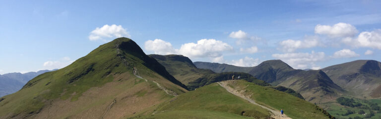
Carn Gelli

Looking ahead you can see the various stiles and gates as you proceed along the high ground. You will have fantastic views to the east. Carn Gelli is an outcrop of rock on the highest point of the ridge. During the day of Thursday 23rd February 1797 this was used by the French to oversee the activities in nearby Fishguard. The main outcrop of rock is easy to scale and it isn’t hard to image some of the French commanders stood here watching the ground and hatching their plans. It isn’t clear if the overall commander, Colonel Tate, ever left his Headquarters at Trehowel Farm (see part 1).

The Pembroke Yeomanry
Lord Cawdor and the Pembroke Yeomanry, with all its attachments, arrived south of Fishguard before last light on the 23rd. Their advance along the now A40 would have been seen by the French, either on Carn Gelli, or by scouts. Lord Cawdor was probably also aware of the French position on Carn Gelli. This is likely due to a retired British Army Officer called ‘Nesbitt’, a possible veteran of the American War of Independence, who happened to be in Fishguard at the time. Mr Nesbitt had busied himself by scouting and recording the French positions since they landed. Although the details around Mr Nesbitt’s full involvement are somewhat scarce in the recorded histories I think it is feasible he had a significant part in what was to happen next.
For our walk head off Carn Gelli to the south to the gate onto the road. The OS map does show another gate to the east but this had fallen out of use last time I visited and could not be accessed. Turn left onto the road and walk in a north eastern direction for 500ms until a road junction. Turn right and walk down the road for approx 200ms.
The French Ambush

I mentioned before (in part 1 of this walk) that the Legion Noire is believed to have consisted of 800 ex-convicts and 600 regular French soldiers. The Last Invasion of Britain is mainly remembered for the former. An unorganised rabble who got drunk, became insubordinate and generally just caused trouble until they surrendered. The actions on the 23rd of February point towards a more disciplined, and serious, approach to achieving the objected set by Hoche.
As Lord Cawdor came to the south of Fishguard he decided to march directly onto Carn Gelli. He led his Pembroke Yeomanry and attachments up the road you are now on from the direction of Dyffryn (so towards you). Meanwhile some of the Legion Noire, possible the Regular element led by one of the Irish Officers, set up a credible ambush position on the south side (right hand side as you look towards Fishguard) of the road. The start of the ambush location is marked by a gate and the beginning of thick hedgerow. Records show it was linear down the side of the road.

Lord Cawdor halted his force 600ms short of this ambush position. Not on the route planner above, but if you wish you can continue down the road to a sharp right bend where there are some buildings. This is Trefwrgi where Lord Cawdor halted. History tells us he was running out of light so decided to withdraw to Fishguard. This was a force consisting of many locals, including Cawdor, who would have been well aware of first and last light timings. More likely, I believe, is that Lord Cawdor sent a scouting party (Mr Nesbitt?) ahead. If so it may be that they entered the fields 150ms to the south west of Trefwrgi and were able to see the rear of the French ambush location. Either way Lord Cawdor withdrew his force to Fishguard. Had he advanced one has to assume history would remember things slightly differently. This seems like an effective ambush position and I feel the French would have had the upper hand here, at least for a while. Success here may have bolstered French morale at least.

Walk back up the road to the junction. The field immediately to your right at the junction is called Parc y Ffrancwr, the Frenchman’s Field. So called because here lies the body of one of the French Soldiers. An engineer from Liverpool called Henry Whiteside, who happened to be in Pembrokeshire at the time, had assembled a small body of sailors from Solva, in North West Pembrokeshire. Arming themselves with what they could find locally they headed off towards Fishguard looking to help out. At Carngowil farm (a little further up) they engaged a party of five French soldiers, killing one and wounding two. It is this soldier who is buried in the field. For those interested in engineering, Henry Whiteside had previously designed and constructed the Smalls Lighthouse.
Head north east up the road and back to the layby.
Fishguard

Not part of this walk, but a good way to finish, is to drive into Fishguard and park near the centre. The West Street public car park is a good place. The Royal Oak Pub sits in the centre on the junction of West Street, High Street and the A487. The Royal Oak is where Lord Cawdor established his Headquarters on Thursday 23rd February 1797. It was to here that two French Officers were escorted around 9pm that same day with a letter from Colonel Tate, calling himself ‘Chef de Brigade’, offering an end to the hostilities.

Lord Cawdor took advantage of the situation and declared he had a superior force under his Command, ‘which is hourly increasing’. He demanded a full surrender and sent a Troop of the Pembroke Yeomanry, led by Major Dudley Ackland, to Trehowel Farm to deliver his terms to Colonel Tate. Tate sent his Second in Command and Aid de Camp to the Royal Oak at 9am on the morning of the 24th of February with a letter authorising them to surrender the Legion Noire. The table on which the surrender was drawn up and signed can still be seen in the Royal Oak. There are a number of other artefacts and paintings relating to the Last Invasion of Britain on the walls.
The French SurrendeR

The French marched down to Goodwick Sands, to the west of Fishguard, and formally surrendered later that day.