Suggested maps for Pen y Fan = OS Explorer Map OL12(1:25,000) & OS Landranger Map 160 (1:50,000)
Pen y Fan
Pen y Fan (known as ‘The Fan’ even though the pronunciation is more like ‘Pen a Van’) is the highest and arguably most significant mountain in the glorious ‘Brecon Beacons’ in South Wales. This National Park is now known as the Bannau Brycheiniog, or ‘the Bannau’ for short. You can read more about the Bannau on Wikipedia here.
The twelfth century writer, Gerald of Wales colourfully describes the Bannau in his account of his Journey through Wales:
…..a range of hills the chief of which is Cadair Arthur, or Arthur’s Chair, so called from two peaks which rise up in the form of a throne. This summit is a very lofty spot and most difficult of access, so that in the minds of simple folk it is thought to have belonged to Arthur, the greatest and most distinguished King of the Britons. On the topmost point of this mountain a spring of water bubbles forth. Its deep basin is square in shape and like a well, but no stream ever runs from it. Trout are said to be found there from time to time.
It is clear that Cadair Arthur is the saddle between the now named summits of Pen y Fan and Corn Du as viewed from the north. This classic route will encompass both.
The Walk
This is a traditional route, for the more demanding Fan Dance click here.
The starting point is the Storey Arms on the A470 at grid SN 982203, and you are advised to get there early to park. Work is being done to improve parking but it is recommended you do not park on the verges of the A470 as the local Police disapprove of this practice. Start by the red telephone box and head straight up the path keeping the Storey Arms Centre and the wooded plantation on your right for 300m.
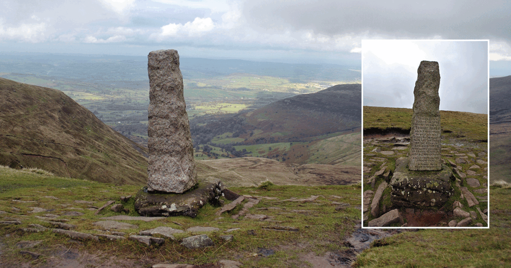
Once past the plantation the well defined track continues straight up for about 800m until you come across a wall at the 590m height contour. Climb over the stile and head down to the river below, this is the Blaen Taf Fawr. You then have another climb for approx 1.4km until you hit the Craig Cwm Llwch ridge. If you have time it is worth walking down the ridge for 400m to the memorial obelisk to young Tommy Jones at grid SO000217.
Llyn Cwm Llwch
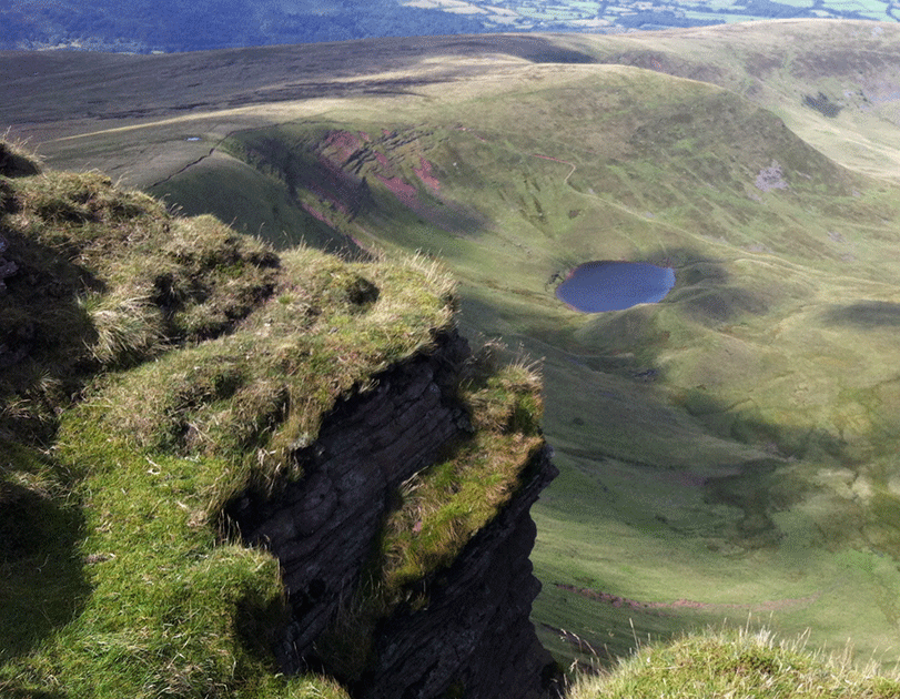
The Craig Cwm Llwch ridge offers a spectacular view over Cwm Llwch towards Brecon. Beneath you lies the majestic Llyn Cwm Llwch. I’ve translated this as the ‘lake in the steep walled mountain basin by the wet muddy place’ but am open to suggestions!. Being in this part of the world the Llyn is steep in legend and an old story tells of a doorway to a magical fairy island.
Corn Du
The final ascent to Corn Du (873m) is a fun little ‘scramble’ although nothing to concern anyone. The bonus is the view from the summit more than compensates for the last climb, especially on a good day! In these days where no one (foolishly) bothers with a map and compass you would be surprised how many people think they are on the summit of Pen y Fan! Mainly because the popular route is a well defined track from the large car park to the south of Storey Arms on the A470 and to the uneducated and ill prepared on this ascent Corn Du looks like the dominate feature.
Talking about being ill prepared, the Bannau has quite a volatile weather system and too frequently walkers have to be assisted back onto the right track back to the car park in bad weather. This is especially true on the descent when it is very easy to pick up the track along the Craig Gwaun Taf heading south east instead on the south west track back down – more about this later as this is your descent route.
Pen y Fan Summit
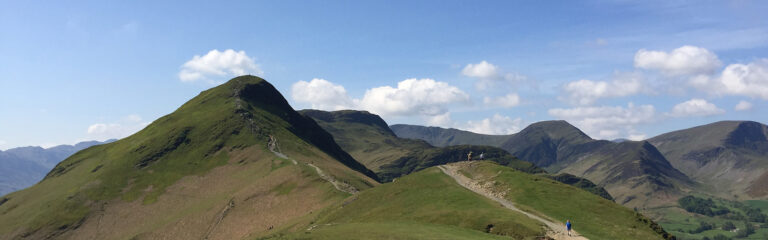
Pen y Fan is to your east so when you are ready drop down into the saddle and is an easy walk to the summit at 886m. The main image of this post shows Pen y Fan from Corn Du and you can see that the path is clearly defined.
I have never found a bubbling spring with trout up here (see intro) but the 370 million year old rock does have interesting ripple patterns on it. The summit cairn is obvious and on a good day you will have to queue for the obligatory picture.
Aside from that enjoy the view! To the north east is the town of Brecon, to your east are the mountains of Cribyn and Fan y Big, to your south east is the Upper Neuadd Reservoir and Taf Fechan Forest valley leading to Merthyr Tydfil, and to the west is Fan Fawr with the Black Mountains in the distance.
The Descent
You have a number of options for descending back to the car park. For this route we will retrace our steps back down Pen y Fan but instead of climbing back up Corn Du we fork left at the track SO010213 keeping Corn Du to our right. Continue south west on the track. Attention needs to be paid here in foggy weather as after 600m on this track you will come to a track junction in a small saddle where you need to be continuing south west down hill (SO005209) and this isn’t immediately obvious due to the track dropping off suddenly . If you find yourself on a incline heading south to south east you have missed this junction so head back.

The track down to the A470 and main car park has been surfaced to cater for the volume of visitors to this iconic mountain so you can’t go wrong! At the big car park there is a toilet facility and catering van. There is a smaller one further north on the left hand side of the road which also has a catering van.
Have fun!