Suggested maps for Wansfell Pike and the Ambleside area – OS Explorer Map OL7 (1:25,000) & OS Landranger Map 90 (1:50,000)
Wansfell Pike via Stock ghyll Force and Troutbeck
Wansfell Pike is a fantastic Lake District hike that starts and finishes in Ambleside. I feel this route offers a wonderful all round Lake District experience of Fells, views, a magnificent Ghyll, ancient woods, and old world villages in less than 11kms and in just over a couple of hours of walking.
In short the route starts and finishes in the historic town of Ambleside, passes the famous Stock Ghyll Force waterfall, climbs Wansfell Pike. Both the ascent and summit of Wansfell Pike offer stunning views on a clear day. Looking back towards Ambleside you can see as far as the Langdale Pikes, and the summit offers a breath-taking view of Windermere. The descent takes you through the unique village of Troutbeck and back to Ambleside via the ancient Skelghyll Wood.

The Route
For this route you can starts anywhere in Ambleside, but I have started at the main Rydal Road car park to the north west of the town. It is advised you get here early to find a space. You can pay a number of ways, including the ‘Pay by Phone’ app. There is also a handy public toilet here. It does charge a small amount and you have to tap a bank card for access.
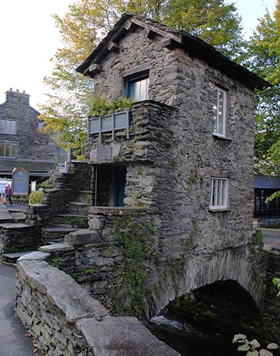
if you are not already familiar with the town then do read our post about Ambleside. The route from the car park will take you past the famous Bridge House and it is worth spending a few minutes exploring this part of town. Another famous Ambleside landmark is the view from the bridge looking up Stockghyll past the Old Mill.
As you walk into town on Rydal Road you will pass a set of lights at a road junction, continue straight on. If you remain on the left side of the road then you will come across the 17th century Market Cross. Across the road and down Compston Road you will find a number of outdoor shops and convenience stores if you need to stock up. For this route carry on east along Rydal Road.
Stock Ghyll Force

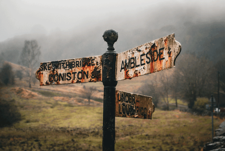
Where Rydal Road turns left and turns into Market Place (there are more shops on Market Place) look straight ahead for a small lane called Stock Ghyll Lane (a Ghyll is an old local term for a waterfall). Follow the lane round to the north (Stock Ghyll force is well signposted) and the lane will gently rise as you leave start to leave Ambleside.
After 400ms leave the lane and pick up the path on the left that leads through the woods to Stock Ghyll Force. The Ghyll itself is 70 feet high and has been a long standing visitor attraction in the area. Spend as much time as you want here and enjoy the beauty and tranquillity.
When you are ready follow a path back to the lane and continue north east until you meet some stone steps over the wall on the right, signposted for Wansfell Pike. The path is fairly easy going and clearly marked.
Wansfell Pike
As you ascend to the summit don’t forgot to look behind you! A wonderful view of the Central Fells will start to open up to the West and this should not be missed. The summit itself offers fantastic views south over Windermere and beyond.

Troutbeck
From the summit pick up the path heading east and gently descend for around 1km until the path meets the walled Nanny Lane. Follow the lane south towards Troutbeck village.


At the end of Nanny Lane you will turn right onto a metalled B Road called Bridge Lane. It is a fairly quiet lane but has no pavements so care is needed as you walk. The route follows the lane for 800ms heading south.
Troutbeck itself has a rich history, dating all the way back to the 12th century when it was first mentioned in the Domesday Book. It was once a thriving community of farmers and shepherds, and you can still see many traditional stone-built houses and farms in the village today.
Continue south down the lane for 800ms until you come across a cluster of properties in the area of Low Fold with a bench on the left next to a road junction, and a Post Office on the right.
Robin Lane
Next to the Post Office a small lane branches off to the right. This is Robin Lane and although starting on a south eastern direction will soon bring you around heading east back to Ambleside. This was another lovely traditional dry stone walled lane. Follow it for 1.2km until you come across a track junction with a large wooden gate on the left hand branch with the Bridle Way clearly marked. Cross over into the field and follow the path down to a ford across a small beck. When I did this route there were sheep in the field so please be mindful if you are walking with dogs.


Skelghyll Wood
Continuing along the path brings you into the ancient Skelghyll Wood, managed by the Woodland Trust. Skelghyll Wood is home to some of the largest trees in the Lake District. There are a few vantage points here that offer fantastic views out over the northern end of Windermere.
I felt this was a nice finish to the walk. The path ambled through the woods and crossed a couple of small becks. Eventually the woods clear on the left and Ambleside comes into view once more.
Once back in Ambleside I chose to remain on Old Lake Road to explore a little before it meets the main Lake Road. You could of course drop down to Lake Road before this. Lake Road has a range of great shops, eateries and refreshment establishments. Nothing like a small reward after a few hours out on the Fells! From here explore Ambleside some more or head up Lake Road and back to the car park.