Showing 1–16 of 20 results
-
Sale!

£13.99 Original price was: £13.99.£11.99Current price is: £11.99.
2023 edition of the AA’s 50 Walks in the Lake District. ‘From gentle strolls to longer hikes’. RRP £13.99 Walks include Buttermere, Keswick, Rydal Water and more! AA 50 Walks in the Lake District brought to you by the Automobile Association, is the perfect outdoors companion for the discerning traveller. This book offers…
-
Sale!
£12.99 Original price was: £12.99.£10.99Current price is: £10.99.
Explore the stunning beauty of the Parc Cenedlaethol Bannau Brychieniog (Brecon Beacons National Park) with this travel map by Ordnance Survey. This sheet map is an essential guide for anyone looking to navigate the Western area of the park, including the wonderful Pen Y Fan. The map provides detailed information on transportation, sports, and other…
-
£18.95
Great Mountain Days in the Lake District: 50 Classic Routes in the Lakeland Fells. mark Richards My personal copy of this Lake District guide is well thumbed. Explore the stunning Lakeland Fells with “Great Mountain Days in the Lake District: 50 Classic Routes.” This comprehensive travel guide, written by Mark Richards and published by Cicerone…
-
Sale!
£12.99 Original price was: £12.99.£10.99Current price is: £10.99.
Lake District Map OL4. Explore the natural beauty of the English Lakes North Western Area with this detailed travel map. The map features the towns of Keswick, Cockermouth & Wigton and provides useful information for transportation. It is a sheet map with a scale of 1:25000 and is published by Ordnance Survey. This is the…
-
Sale!
£12.99 Original price was: £12.99.£10.99Current price is: £10.99.
Lake District Map OL5. Explore the beauty of the English Lakes North-Eastern Area with this detailed Lake District map by Ordnance Survey. The map is printed on a sheet of high-quality paper, providing clear and accurate details of the area. It includes Penrith, Patterdale & Caldbeck, making it an essential guide for both locals and…
-
Sale!
£12.99 Original price was: £12.99.£10.99Current price is: £10.99.
Lake District map OS OL7. Explore the stunning beauty of the English Lakes South-Eastern Area with this detailed and accurate map from Ordnance Survey. Discover Windermere, Ambleside, Grasmere, Kendal and Silverdale as you navigate through the picturesque landscape. The map is printed in English on a high-quality sheet, with a scale of 1:25000 for accurate…
-
Sale!
£12.99 Original price was: £12.99.£11.99Current price is: £11.99.
Lake District – Outstanding Circular Walks. Ordnance Survey Pathfinder series. 2022 Edition. RRP £12.99 28 Great country walks from 3 to 10 miles. Clear large scale Ordnance Survey route maps GPS references for all route waypoints. Where to park, good pubs and place of interest en route. 160 miles of walking amid the majestic…
-
Sale!
£49.99 Original price was: £49.99.£34.99Current price is: £34.99.
SILVA Expedition 4 Compass. Military – 6400 Mils. Green lanyard. SILVA are the industry standard for Military compasses. The SILVA Expedition 4 compass is a must-have for all outdoors people. This is the perfect tool to help you get the most out of your outdoor adventures. The Expedition 4 provides you with the…
-
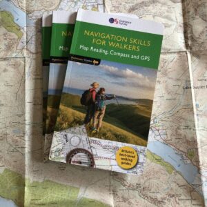
Sale!
£12.99 Original price was: £12.99.£11.99Current price is: £11.99.
Product Information Discover more of the great outdoors with Navigation Skills for Walkers and Pathfinder (R) Guides. Build confidence and competence in reading maps: using grid references, contour interpretation and visualising terrain. Learn how to use a compass, with map and compass navigation: taking a bearing, magnetic variation and `aiming off’. Make the most of…
-
Sale!
£12.99 Original price was: £12.99.£10.99Current price is: £10.99.
OS Explorer Map OL 17 Snowdon/Yr Wyddfa, by Ordnance Survey. 1:25,000 Explore the beautiful Yr Wyddfa (Snowdon) and Conwy Valley with this detailed OS Explorer Map OL 17. This sheet map is folded for easy carrying and provides accurate information on the landscape, walking routes, and tourist attractions in the area. Created by Ordnance Survey,…
-
Sale!
£12.99 Original price was: £12.99.£10.99Current price is: £10.99.
Ordnance Survey Map OL24 1:25,000 The Peak District – White Peak Area This map covers Buxton, Bakewell, Matlock and Dove Dale. Brand New! OS Explorer is the Ordnance Survey’s most detailed map and is recommended for anyone enjoying outdoor activities like walking, horse riding and off-road cycling. The OS Explorer range of OL maps now…
-
Sale!
£12.99 Original price was: £12.99.£10.99Current price is: £10.99.
Explore the picturesque South-Western area of the English Lakes with this detailed Coniston, Ulverston & Barrow-in-Furness map by Ordnance Survey. With a map scale of 1:25000, this sheet map provides accurate and up-to-date information on transportation, making it an ideal companion for explorers and travellers alike. The map is printed in English and features the…
-
Discover the breathtaking landscapes of Scotland with the latest Ordnance Survey Map 392, covering the majestic Ben Nevis and the historic town of Fort William. Designed for walking, cycling, and adventure enthusiasts alike, this brand-new map is your gateway to exploring Scotland’s highest mountains and stunning lowlands with the most up-to-date navigation information. Key Benefits…
-
Sale!
£12.99 Original price was: £12.99.£10.99Current price is: £10.99.
Explore the rugged landscapes of North Pembrokeshire with the OS Map OL35, your reliable guide to this majestic area of Wales. Whether you are planning a scenic hike, a coastal walk, or an adventure into the Welsh wilds, this detailed OS map provides you with comprehensive information and accuracy you need. New and sealed, it…
-
Sale!
£37.99 Original price was: £37.99.£29.99Current price is: £29.99.
SILVA Expedition 4 Compass. Duke of Edinburgh scheme ‘recommended kit’. RRP £37.99 With FREE Ordnance Survey Map Reading Guide. SILVA are the industry standard for compasses. Features include a 360 degree rotating compass housing, compass scales for 1:25k and 1:50k maps (Ordnance Survey (OS) standard), and floating compass needle with red tip to…
-
Sale!
£29.99 Original price was: £29.99.£22.99Current price is: £22.99.
SILVA Map Case Large. RRP 29.99 The SILVA large map case is the perfect companion for your outdoor adventures! With its extra-large size, this map case gives you space for a full-sized map in addition to compasses and other map reading tools. It features a zip-seal closure with a heavy-duty metal zip, keeping your maps…